Abstract
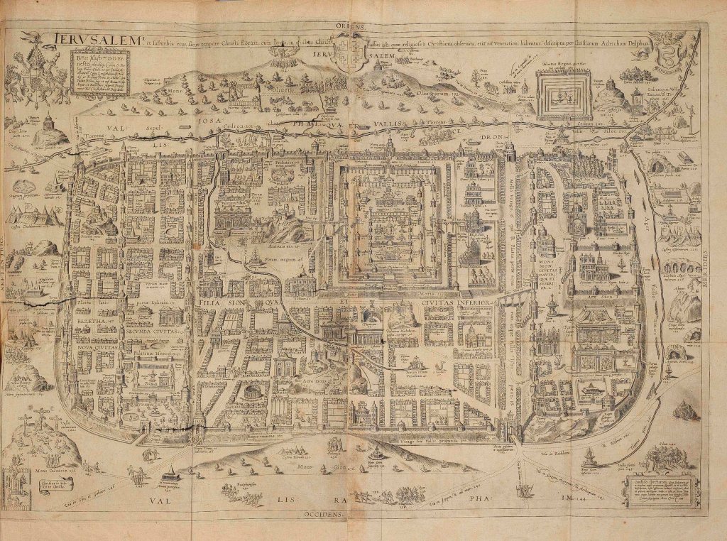
The essay examines an original map of Jerusalem drawn in 1584 by Christian Kruik van Adrichem (1533-1585), a Dutch theologian and humanist. The fold-out map, which was intended to be a historical and devotional guide based on accounts of travelers, portrayed an imagined Jerusalem at the time of Jesus, including the City of David and Mount Zion, Mount Moriah, and the Via Dolorosa. By revisiting the idea of the Theatrum during the 16th century, I argue that Adrichem’s map conforms to the convention of cartography during the late medieval period and was intended as a mnemonic aimed not just to illustrate but to commit Biblical texts to memory. To this end, I will analyze the maze-like enclaves, the anachronistic architecture, and use of symbols. Adrichem’s cartographic practice serves as evidence of how Christians in Western Europe viewed Jerusalem with greater importance after the invention of the printing press in the mid-15th century which created a revolution in the proliferation of sacred texts and in fuelling interests for Biblical places. Cartography of the Terrae Sanctae addressed the need of prospective pilgrims for visual authenticity of biblical places, which relies not so much on an accurate image of Jerusalem but on the capacity of the map as imagines agentes. As printing presses made texts available on a mass scale, maps served as an index of the globalization of interests, informed by exploration, trade and commerce during the early modern period, striking a contrast with the relative peripheral stature of Jerusalem in the Ottoman Empire.
Keywords: jerusalem, cartography, print technology, biblical history, van adrichem, theatrum, imago agens, ottoman empire, cultural technique
